Yorkshire One, Two or Three Peaks Weekender
Whernside
We’ll meet at Ribblehead (you can get the train from Horton-in-Ribblesdale in the morning) and from there we’ll target Yorkshire’s highest peak via an extended route.
Admiring the magnificent Ribblehead Viaduct close up first of all, we’ll then follow the Settle-Carlisle line a little way across the moor before leaving the ‘tourist path’ and focusing instead on the Craven Way, before visiting the elusive Whernside Tarns on Knoutberry Hill. It's a steady climb up to the main summit ridge where we’ll feel on top of the world (or Yorkshire, at least!) at 736m above sea level, with views across the Dales, down to the viaduct and if we're lucky, even to the Lake District! From here we descend to the valley bottom and through farmland until we pass directly under the viaduct and back to the Station Inn at Ribblehead for refreshments.
The initial descent from Whernside is steep and rocky so you may prefer to bring poles with you.
10 miles (16km) with 1800 feet (555m) of ascent and the same in descent
Ingleborough
We meet at Ribblehead once more before ascending to one of the most interesting summits in Britain.
Getting the most of the ascent out of the way early on, our route takes us along the edge of subsidiary peaks Park Fell and Simon Fell, a fantastic high level approach with views of Ingleborough and Morecambe Bay. Our goal is the ancient ‘hill fort’ of Ingleborough with its archaeological features and incredible views across the Dales, Lakes, Lancashire and the coast. Our descent from this 723m peak becomes even more interesting as we pass Little Ingleborough, look for fossils, gaze into Gaping Gill, experience towering Trow Gill and marvel at the limestone pavement! We return to the welcoming inns and cafes of Horton-in-Ribblesdale via a section of the Pennine Bridleway and more limestone pavement.
This is a grand linear walk connected by the Settle-Carlisle Railway. It's worth parking in Horton-in-Ribblesdale and getting the train to Ribblehead in the morning to prevent a lengthy wait at the end.
11 miles (18km) with 2300 feet of ascent (710m) and 2550 feet (785m) of descent
Pen-y-ghent
Our final walk is the lower of the famous ‘Three Peaks’ at 694m above sea level but still undoubtedly a classic.
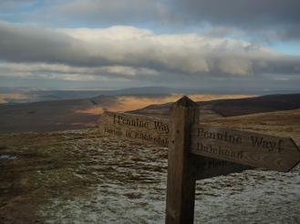
We first ascend Pen-y-ghent via the direct Three Peaks route from Horton-in-Ribblesdale before taking in the wide-ranging views from the summit. With a whole day available, we then detour to one of the Dales’ most unusual geological features, the mysterious Hull Pot before joining the brand new Three Peaks path to join an extended stretch of the Pennine Way. Once more we finish in Horton-in-Ribblesdale, having covered up to 30 miles and 6000 feet of ascent over the weekend!
There is a short section of ascent on this walk where you may need to use your hands.
7 miles (11km) with 1800 feet (550m) of ascent & the same in descent.
All of these three walks include some steep and rocky ascents and descents, as well as boggy terrain. A reasonable level of fitness will be required as well as sturdy ankle supporting boots, waterproofs and spare warm clothing.
Ribblehead is served directly by the Settle-Carlisle Railway and some bus services: http://www.dalesbus.org
Please see our Links page for ideas on where to stay in the area
We’ll meet at Ribblehead (you can get the train from Horton-in-Ribblesdale in the morning) and from there we’ll target Yorkshire’s highest peak via an extended route.
Admiring the magnificent Ribblehead Viaduct close up first of all, we’ll then follow the Settle-Carlisle line a little way across the moor before leaving the ‘tourist path’ and focusing instead on the Craven Way, before visiting the elusive Whernside Tarns on Knoutberry Hill. It's a steady climb up to the main summit ridge where we’ll feel on top of the world (or Yorkshire, at least!) at 736m above sea level, with views across the Dales, down to the viaduct and if we're lucky, even to the Lake District! From here we descend to the valley bottom and through farmland until we pass directly under the viaduct and back to the Station Inn at Ribblehead for refreshments.
The initial descent from Whernside is steep and rocky so you may prefer to bring poles with you.
10 miles (16km) with 1800 feet (555m) of ascent and the same in descent
Ingleborough
We meet at Ribblehead once more before ascending to one of the most interesting summits in Britain.
Getting the most of the ascent out of the way early on, our route takes us along the edge of subsidiary peaks Park Fell and Simon Fell, a fantastic high level approach with views of Ingleborough and Morecambe Bay. Our goal is the ancient ‘hill fort’ of Ingleborough with its archaeological features and incredible views across the Dales, Lakes, Lancashire and the coast. Our descent from this 723m peak becomes even more interesting as we pass Little Ingleborough, look for fossils, gaze into Gaping Gill, experience towering Trow Gill and marvel at the limestone pavement! We return to the welcoming inns and cafes of Horton-in-Ribblesdale via a section of the Pennine Bridleway and more limestone pavement.
This is a grand linear walk connected by the Settle-Carlisle Railway. It's worth parking in Horton-in-Ribblesdale and getting the train to Ribblehead in the morning to prevent a lengthy wait at the end.
11 miles (18km) with 2300 feet of ascent (710m) and 2550 feet (785m) of descent
Pen-y-ghent
Our final walk is the lower of the famous ‘Three Peaks’ at 694m above sea level but still undoubtedly a classic.
We first ascend Pen-y-ghent via the direct Three Peaks route from Horton-in-Ribblesdale before taking in the wide-ranging views from the summit. With a whole day available, we then detour to one of the Dales’ most unusual geological features, the mysterious Hull Pot before joining the brand new Three Peaks path to join an extended stretch of the Pennine Way. Once more we finish in Horton-in-Ribblesdale, having covered up to 30 miles and 6000 feet of ascent over the weekend!
There is a short section of ascent on this walk where you may need to use your hands.
7 miles (11km) with 1800 feet (550m) of ascent & the same in descent.
All of these three walks include some steep and rocky ascents and descents, as well as boggy terrain. A reasonable level of fitness will be required as well as sturdy ankle supporting boots, waterproofs and spare warm clothing.
Ribblehead is served directly by the Settle-Carlisle Railway and some bus services: http://www.dalesbus.org
Please see our Links page for ideas on where to stay in the area
